North Turramurra is big on paper, about 1,167 hectares, but by my overlay roughly two-thirds of it is Ku-ring-gai Chase National Park. The houses are built up around Bobbin Head Road, with bush on three sides. That's the setting for every garden here: a narrow strip of clay and sandstone, right on the edge of a national park.
This guide is part of my series on North Shore suburbs. I've overlaid the North Turramurra suburb boundary on the NSW Government's soil and vegetation maps, and looked separately at the part outside the national park, where people actually garden.
What grew in North Turramurra before 1788
| Plant community | Whole suburb | Outside the national park |
|---|---|---|
| Sydney Turpentine Ironbark Forest | about 19% | about 53% |
| Sydney Coastal Sandstone Gully Forest | about 38% | about 21.5% |
| Sydney Coastal Sandstone Riparian Forest | about 16% | about 7% |
| Sydney Coastal Sandstone Bloodwood Shrub Forest | about 9% | under 1% |
| Sydney Coastal Shale-Sandstone Forest | about 5% | about 5% |
| Sydney Enriched Sandstone Moist Forest | about 5% | about 5% |
| Blue Gum High Forest | about 1% | about 3% |
Turpentine-ironbark where the houses are
On the ridge where the suburb was built, the main community was Sydney Turpentine-Ironbark Forest. It's critically endangered, with about 96% cleared across its range. BioNet describes it as a tall forest on shale or sheltered shale-sandstone soils, with turpentine (Syncarpia glomulifera) very frequently in the canopy and a grassy ground layer.
When the botanist George Caley reached Lovers Jump Creek in February 1805, near where Burns and Chase roads now meet, he noticed mostly blue gum and she-oak.
Sandstone gullies and creeks
The national park side is sandstone country. The gullies were Sydney Coastal Sandstone Gully Forest, with Sydney peppermint (Eucalyptus piperita) and Sydney red gum over NSW Christmas bush and old man banksia. Along the creeks running to Cowan Creek, the riparian forest had coachwood (Ceratopetalum apetalum), water gum and black wattle (Callicoma serratifolia) under red gum and peppermint.
My which plant community guide explains how to work out which of these communities your block belonged to.
North Turramurra soil type: clay ridge, sandstone edges
| Soil landscape | Whole suburb | Outside the national park | What it's like |
|---|---|---|---|
| Lucas Heights | about 12.5% | about 34% | Hard-setting yellow clay soils on the Mittagong Formation, stony, low fertility |
| Gymea | about 11% | about 26% | Sandy soils with rock benches, permeable, very low fertility |
| Hawkesbury | about 45% | about 15% | Steep, rocky, shallow sand, extreme erosion hazard |
| Blacktown | about 2.5% | about 8% | Shale clay, poorly drained lower down, highly plastic, moderately reactive |
| Glenorie | about 2.4% | about 7% | Friable loam over deep red and yellow shale clay |
| Lambert | about 20.5% | about 5% | Shallow sandy soils on exposed ridges, perched water tables |
| Disturbed terrain | about 1.3% | about 4% | Fill and cut ground; soil depends on the fill |
What that means in the garden
On the ridge (Lucas Heights, Blacktown and Glenorie): most of the houses sit on clay. Lucas Heights soil is a hard-setting, stony yellow clay, low in fertility and slow to take water. The soil survey notes the subsoil is occasionally sodic and impermeable. The patches of Blacktown and Glenorie are deeper shale clay. Either way: add organic matter to the surface, mulch well, and make sure water has somewhere to go.
On the edges (Gymea, Hawkesbury and Lambert): as soon as a block falls away towards the bush, it's sandstone. These are very low-fertility sandy soils, deficient in nitrogen and phosphorus. On the Lambert ridges the survey notes perched water tables, so a sandy patch can still be wet. Local natives grow best here. My native plant finder is a good place to start.
Disturbed terrain: the soil map also marks patches where the original soil has been replaced by fill or cut away. The Dictionary of Sydney notes that after 1954, rubbish from West Pymble went to the tip at North Turramurra. If you're on one of these patches, find out what's under you before digging deep or planting big trees.
How the 1800s changed North Turramurra's soil
The first land grants nearby went to a Pymble settler in 1823 and to John Ayre in 1836. Growth began around Bobbin Head Road in the 1860s, when the large early estates were sold. Bobbin Head Road follows an Aboriginal track to the headwaters of Cowan Creek.
A cluster of farmers and orchardists of Irish descent settled around Bobbin Head Road and Bannockburn Road, and the area was known unofficially as Irish Town until 1915. When Turramurra North Public School opened in 1914, there were orchards, dairies, poultry farms and market gardens around it. The area stayed semi-rural through the 1920s and, according to the Dictionary of Sydney, until 1950.
What that meant for the soil:
- Clearing the ridge for farms removed most of the turpentine-ironbark forest from the land outside the park.
- Small farms, orchards and dairies worked the clay and sandy soils for decades, much later than in the railway suburbs.
- The steep sandstone around the suburb, which the soil survey rates as generally not capable of urban development, stayed as bush, and much of it is now Ku-ring-gai Chase National Park.
North Turramurra gardens today
Late and fast development
The Housing Commission resumed land around Keats Road in 1950 and built houses there in 1958 and 1959. Major growth came in the 1960s, and zoning changes in the 1970s allowed big estates to be subdivided. So most North Turramurra gardens are post-war, and the council lists no heritage conservation areas here.
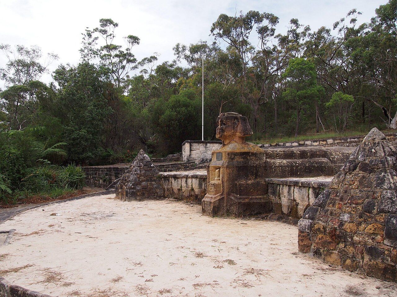
There are some older landmarks. Eccleston du Faur, who was responsible for establishing Ku-ring-gai Chase National Park, built his house Flowton on Bobbin Head Road. It's now part of Lady Davidson Hospital, set up in 1915 for returned soldiers. Patients were expected to work in the garden, and one, Private William Shirley, spent a year and a half carving a sphinx from solid rock nearby instead. It later became an Anzac memorial.
Living next to a national park
With bushland on three sides, the most important thing a North Turramurra garden can do is not leak weeds into the park. The soil survey notes that privet, lantana, morning glory and wandering jew wash into the sandstone valleys with sediment. My weeds guide covers which garden plants to replace first. Mulch, local natives and keeping garden waste out of the bush all help.
Working on your garden in North Turramurra
I work across Sydney's North Shore, including North Turramurra (see my Ku-ring-gai area page). Nearby suburbs in this series are Turramurra, North Wahroonga, St Ives Chase and St Ives.
Sources
- NSW DCCEEW, State Vegetation Type Map, pre-1750 Plant Community Types (map service VIS/SVTM_NSW_1750_PCT), queried 13 Oct 2026
- NSW Spatial Services, NSW Administrative Boundaries, Suburb layer (North Turramurra, 1,167 ha) and NPWS Reserve layer (overlay: about 792 ha, 68%, inside Ku-ring-gai Chase National Park)
- BioNet Vegetation Classification, PCT definitions 3262, 3595, 3596, 3593 and 3259
- NSW Threatened Species profile, Sydney Turpentine-Ironbark Forest in the Sydney Basin Bioregion
- NSW DCCEEW, Soil Landscapes of the Sydney 1:100,000 Sheet (Chapman & Murphy 1989; map ed. 4, 2009), map service Soil_Landscape/Sydney queried 13 Oct 2026
- NSW DCCEEW eSPADE, Lucas Heights (lh) soil landscape report, from Chapman & Murphy 1989
- NSW DCCEEW eSPADE, Gymea (gy) soil landscape report, from Chapman & Murphy 1989
- NSW DCCEEW eSPADE, Hawkesbury (ha) soil landscape report, from Chapman & Murphy 1989
- NSW DCCEEW eSPADE, Lambert (la) soil landscape report, from Chapman & Murphy 1989
- NSW DCCEEW eSPADE, Blacktown (bt) soil landscape report
- NSW DCCEEW eSPADE, Disturbed Terrain (xx) soil landscape report
- Rowland J, North Turramurra, Dictionary of Sydney, 2011
- Cameron-Smith B, West Pymble, Dictionary of Sydney, 2012